St George’s gets Google mapped
- 7 August 2013
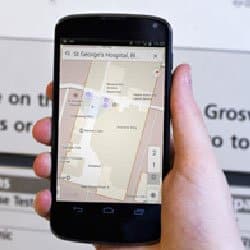
St George’s Healthcare NHS Trust has worked with Google to publish an interactive indoor hospital map.
Patients and visitors can use the Google Maps website or apps to navigate the 14 hectare south west London hospital site.
Published as part of Google’s indoor mapping programme, it shows the trust’s many buildings, wards and points of interest such as stairs, toilets and coffee shops across seven wings, some of which span seven storeys.
The maps are available on the Google Maps website and will be available on the Google Maps Android app and the Google Maps iOS app later this month. The indoor map layer is activated when zooming in on the St George’s Hospital site.
On mobile phones a sidebar allows for different floors of the hospital to be loaded while zooming in on the floor level shows the wards and points of interest on the map.
St George’s project lead Colin Wren says this is the first interactive indoor hospital map in the UK
"Coming to hospital can be an anxious time for people, so we are determined to make it easier for patients and visitors to get to their appointments on time and to help them to find the wards that their friends and family are staying in quickly and easily,” he said.
The trust released a patient app last year which included a hospital map, which was much less detailed. Wren said the new map is part of the Google Maps platform so people do not need to download a specific app to use it.